By all accounts the summer of 2002 was shaping up to be just another typical Texas summer - hot, humid and no rainfall. Canyon Lake, Texas is a water recreation area that capitalizes on the Guadalupe River and Canyon Lake, attracting people from all over to the beautiful Hill Country near the old German settlement of New Braunfels, located between San Antonio and Austin.
The Upper Guadalupe River begins as a spring west of Hunt, Texas, and flows through a limestone bed lined with huge Cypress, Pecan, Oak, Elm, Sycamore and other varieties of trees past cattle ranches and the towns of Hunt, Kerrville, Comfort, Sisterdale, Bergheim, Bulverde and Spring Branch down to Canyon Lake about 87 miles below the headwaters. The uppermost reaches of the river are narrow and shallow, with water generally flowing a few inches deep and less than 100 cfs (cubic feet per second). As the river winds its way toward Canyon Lake it widens a little and gets slightly deeper, though the Guadalupe has cut a deep trough in the limestone walls of either side over the years, whenever the river has flooded. Nearer the lake it flows at about 100 - 500 cfs most of the time, and is a beautiful place to paddle a canoe or kayak. The rapids are Class I - II, though they were once Class I - III until the floods of 1997-98 flattened out most of them, taming the river slightly. It is basically undeveloped, though San Antonio is rapidly encroaching in Kendall and western Comal Counties. Over the years I have seen several floods hit this area. Usually, they come up, rage like a banshee down to the lake, then the river returns to normal within a couple of days. For those of us who love to run the river we talk about hitting it in flood stage, because that is about the only time we can get a real thrill out of the rapids and waterfalls. Whenever it rains we usually gather at our favorite access points and wait until the river is falling to a safe level, then we climb into our canoes and kayaks and take off on a great ride. The highest level at which I have ever paddled the river was 3,850 cfs last November (2001), right after a good rain that raised the level to over 9,000 cfs briefly.
One of the dangers of floods of the Guadalupe River is the depositing of large Cypress trees in the river. Cypress trees love a lot of water, so they grow along the banks of the river, often times with their roots partially exposed. Flood waters rage with a powerful force greater than any other on earth, and frequently they displace those trees and drop them into the river where they follow the natural streambed until they reach Canyon Lake. Other dangers include swarms of fireants, snakes, spiders, piles of debris, and all manner of contaminants including animal feces and urine, fertilizers, building materials, automobiles and chemical toilets. Generally, these contaminants are limited to trees, fireants and snakes and chemical contaminants such as fertilizers, but big floods reach up to where people have encroached on the river banks, building structures too close to the edge and parking cars where they can be swept away by flood waters. Of course, there are also people who try to drive across low water bridges while they are being overrun by the river, and sometimes they and their cars end up in the river. In 1997, the Upper Guadalupe River flooded significantly, reaching levels of over 167,000 cfs for a brief time before settling down to a normal flow. Because of the lack of commercial and residential development there is usually a low rate of building materials and such being deposited into the river. But, as the river winds it cuts across land and scours everything in its path. Much of the debris is from trees, but part of it also comes from private and public campgrounds. The 1997 flood was typical, rising fast, flashing downriver to Canyon Lake, then returning the river to its usual mild self after a few hours to a few days. The 1998 flood was primarily in Canyon Lake and on the Lower Guadalupe River, where it did extensive damage and took 43 lives of humans as well as about 75,000 head of cattle. The 1998 flood hit in a deluge, dropping some 44 inches of rain on the New Braunfels area in about 4 hours, raising the river from about 200 cfs to over 100,000 cfs within a few minutes. It removed houses from their foundations and deposited them into the river where they floated like giant houseboats until they disintegrated from the pressures of the raging river. That flood took out most of the tube and raft liveries that operate along the Lower Guad, as well as houses that were built a little too close to the flood plain. It closed the river for recreational uses for several months while a clean-up was being done and while the Corps of Engineers bled off excess water from Canyon Lake flood gates at a rate of 5,000 - 5,800 cfs. Closing the river to tubing and rafting was a financial disaster to the liveries that cater to recreational users of the river and the lake. While New Braunfels is a city of several thousand people the community of Sattler, located just below Canyon Dam, is highly dependent upon river recreation for its revenue flow. Memorial Day is the traditional start of the river recreation season on the Guadalupe River, and 2002 was no exception. The Lower River attracted approximately 250,000 people per day over the weekend, even though the water was already getting too low to enjoy - so low that even tubes have a difficult time getting downriver. But hey, when it is hot outside even a little water in the river is attractive to many people, so they came in droves and the campgrounds were filled to maximum capacity. It looked like 2002 was going to be a banner year. However, it did not rain in June until it started on about June 27, when just a little water fell in the Guadalupe Valley. It raised the river enough to make tubing a lot more fun, but still far from adequate for enjoyable canoe, kayak and raft trips.
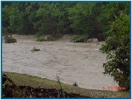
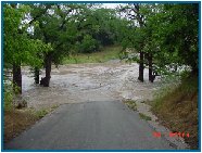
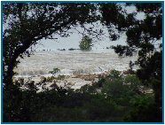
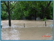
By June 29, it looked like we were not going to get an adequate rainfall to sustain the river throughout the summer. Canyon Lake was already below the 909 feet (above mean sea level) that is the conservation level of the lake, as established by Army Corps of Engineers specifications. Then, the rains started to fall. A low pressure depression in the Gulf of Mexico blew into the area and it started to pour, just in time for the July 4th weekend, the second of three big weekends between the Memorial Day to Labor Day season. As luck would have it, the rains did not stop, and by June 30, the river had to be closed to recreational uses due to swift currents and lightning. Not many people were concerned because, as a friend of mine stated, "If it does not rain by mid-June, then it is not going to rain all summer. It never rains in Texas in July." Normally, that statement would have been right on target. My friend has been a resident of this area for nearly 30 years, and has witnessed the changing seasons enough times to know what to expect. July 4th weekend came, and the river was still rising, peaking on July 3rd, at 107,000 cfs at the Spring Branch gauge on the Upper Guad, some 43.75 feet deep where it is normally about 2 feet deep. That weekend was wiped out for the liveries serving the river and marinas operating on the lake, which was filling fast. Canyon Lake has never overflowed the spillway at any time since its construction, and nobody knew what would happen if it did. Along the river everybody was watching as the river flooded, washing out low water bridges and smaller trees along the river bank. The Comal County Sheriff's Department dispatched officers to strategic areas to prevent people from attempting to cross flooded bridges and to respond in case of emergencies. People gathered at vantage points where they could watch the phenomenon, and it was somewhat of a party atmosphere, though the tube and raft liveries were starting to fear the worst as they saw the second of their biggest weekends wiped out. Unlike past years, the rain did not stop. It flooded up and down the river, and the rains continued to fall from Kerrville all the way down to the Gulf of Mexico. Because of lower river flooding the engineers at Canyon Lake could not open the flood gates to begin a release of rising waters, and the result was that the lake reached maximum capacity by July 7, when it began overflowing the spillway and washing down into Sattler. The overflow rose to more than 9 feet above the spillway taking out homes and businesses in the path of the spillway and along the Guadalupe River below the dam. A low water bridge across a creek on Dam Access Road was wiped out by the raging floodwaters, and debris from the bridge started taking out other physical objects in its path. The river makes a "U" shaped bend down to the area called Horseshoe Falls, where a riverfront housing development sits, then proceeds down to another "U" shaped bend generally referred to as "the tube loop", where the Guadalupe River crosses FM 306 in Sattler twice.
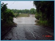
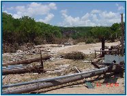
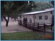
Raging floodwaters severely damaged or destroyed several homes and businesses along the river within a couple miles of the dam, and buried FM 306, closing it to all traffic for several days. Other crossings of FM 306 to the northwest, where the Hill Country dips to creek bottoms, flooded and was closed trapping many people between segments of flooded roadway. Rumors flew, from Comal County officals, disaster relief workers and the news media, that the FM 306 bridge by Maricopa Lodge had been destroyed, effectively cutting off everything to the northwest of Sattler. Actually, the bridge was not damaged, though the approach apron of asphalt was partially damaged. The chunks of concrete, steel and asphalt that people saw moving downriver were probably from homes, businesses and the low water bridge on Dam Access Road that were being carried downriver by the massive flow of floodwaters coming over the spillway. Maricopa Lodge was partially damaged and sustained significant interior water damage. Whitewater Sports' office building and tube shack were completely wiped out and destroyed by a wall of water coming down from the mountain directly behind it. Substantial tree damage along the river is apparent everywhere. By July 17, the water was generally back within its banks, though a flood condition is still prevalent. Contamination from debris and chemicals is a major concern for all who live along the river, operate river-oriented businesses or use the river from recreational purposes. Comal County Department of Health had originally closed the Guadalupe River and Canyon Lake, within Comal County, to all recreational uses until July 20, but has since modified that closing order with a target date for re-opening the river sometime after Labor Day, depending upon when the river and lake show contaminant levels of bacteria, germs and pathogens below the safe limits established by the Centers for Disease Control (CDC). The flood of 2002, has caused enormous financial damage to the Canyon Lake area. Most employees of the liveries catering to canoeing, kayaking, rafting and tubing have lost their jobs. Other business, whose own properties were not damaged, are suffering from the loss of revenues as the area is almost a ghost town now. Some residents will get work during the river clean-up once it starts, but that is still several weeks away, at best. The lake, which was starting to fall, has again started rising in response to additional rains upriver that are flowing into the lake from Kerrville, Comfort and other areas above the lake. Even after a week of no rains, the lake level was still about 1.75 feet above the spillway, and then it started to rain again on July 14, with rain coming each day since. It looks like rain will fall again today. If there is a high point about this disaster, then it lies with the fact that so few have perished this time around. Unlike previous floods, this one did not come as a flash flood, but rather as a river and lake steadily rising from days of continual rains. That fact, and the seriousness with which most people treated the river this time around, probably were responsible for a lower death rate that is normal when the Guadalupe River overflows its banks. But, the human toll is not measured in deaths alone, and the financial damage to the area is great. Lost jobs and income are hard to replace, and many have been stricken with unforeseen problems that now threaten their very survival. Disaster relief is far too inadequate to compensate those whose livelihoods have been disrupted and whose uninsured possessions and properties were damaged or destroyed. It will be some time before a true accounting can be made, but this may well be recorded as the most severe flood damage ever in the Guadalupe Valley. Lest we overlook other damage caused by these floods, it should be noted that significant flooding and flood damage also occurred on the Medina, Blanco and San Antonio Rivers. The earthen dam at Medina Lake was believed to be in danger of collapse as it approached the top (Medina Dam has no spillway), but that proved not to be the case. Still, much property damage occurred in and along the Medina River from Medina down to below San Antonio, where the Medina flows into the San Antonio River. Thankfully, the Medina and Blanco Rivers are much less developed that even the Upper Guadalupe, so damage in that area was more limited, and as no commercial river business of any significance exists there the loss of river recreation revenues and support services was greatly less than in Comal County. |
Copyright © 2002-2004, Marc W. McCord dba CobraGraphics. All rights reserved. CobraGraphics and Lone STar Paddler are exclusive tradenames and trademarks of Marc W. McCord dba CobraGraphics. The textual, graphic, audio, and audio/visual material in this site is protected by United States copyright law and international treaties. You may not copy, distribute, or use these materials except for your personal, non-commercial use. Any trademarks are the property of their respective owners. All original photographic images on this web site are the exclusive property of Marc W. McCord and may not be copied, duplicated, reproduced, distributed or used in any manner without prior written permission under penalty of US and International laws and treaties. |